Chinese hi-tech has long ceased to be an object of ridicule and, in conjunction with the price factor, makes it increasingly attract attention, breaking old stereotypes.
The South S750-G2 GNSS receiver attracted attention with its declared specifications and low price, and the temptation to test this device in the field was great. The first thing that pleased in the S750-G2 is its ability to work from commercial RTK networks designed for "serious", "adult" dual-frequency phase geodetic receivers in the NTRIP protocol. This is despite the fact that the S750 is single-frequency, despite its multi-system GPS (L1, C / A), GLONASS (L1) and can only process code differential corrections. The ability of the device to operate in RTK mode from an internal antenna, as well as its accuracy characteristics under various shooting conditions, at various distances from the corrective base station, its capabilities and features - all this is subject to verification and study in this review.
The TTX on the S750-G2 states that:
Let's check this last parameter. Why we disassemble the S750-G2 and look at the design
The photo shows that the form factor is completely borrowed from the Trimble GeoExplorer series, as well as the name of the technology for suppressing multipath "Everest", by the way. However, strong high-quality plastic, a thick rubber gasket and the “borrowed” design itself make it possible to believe in the security of the device rather than not. I wouldn't put it in water though. There is no annular sealant protection of the fastening screws that tighten the case. Those. on them leading into the body sooner or later will fall if you bathe him regularly. But a fall on concrete (but not a screen, perhaps) will withstand it. The design features also include the branded stylus, which sits in its socket so tightly that it is not surprising that it is tied to the body, it seems, with a Kevlar cord, since only such material is able to withstand the force that has to be applied to pull the stylus out of the cord. nests ;) However, with time and development, the process becomes easier.
So how well does it work?
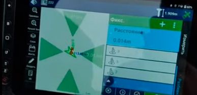
Field trials were carried out to evaluate performance/measurements under various conditions. The measurement result of the S750-G2 GNSS receiver was compared with the measurement results of the Trimble R7 dual-system dual-frequency GNSS geodetic class receiver, with the reception of corrections from a single, already mentioned, base station generating a full-fledged phase RTK GPS / GLONASS stream of the RTCM 3.0 standard, as well as the measurement results of a simple tourist GPS receiver Garmin eTrex 30, working offline.
A series of tests on the outskirts of the forest, the distance from the corrective base station is 40 km.
Measurements with the S750-G2 receiver
• offline with built-in GNSS antenna; • offline with an external GNSS antenna; • in the mode of receiving corrections with a built-in GNSS antenna; • in the mode of receiving corrections with an external GNSS antenna.
Each of the four options included seven measurements performed at different times within a three-hour interval. In other words, the measurements were made not one after another, which would give a smaller resulting error (higher convergence of the result), but after significant pauses for a significant change in the observation conditions from the point of view of satellite geometry. This approach models real measurements and, consequently, the resulting errors much more accurately.
It should be noted right away that the use of an external antenna for the S750-G2 did not provide any advantages in measurements and did not reveal any difference in the accuracy assessment.


 Contact us