NovAtel SPAN-CPT7

NovAtel SPAN-CPT7
NovAtel SPAN-CPT7
Span-CRT7
On request
Not available
NovAtel SPAN-CPT7

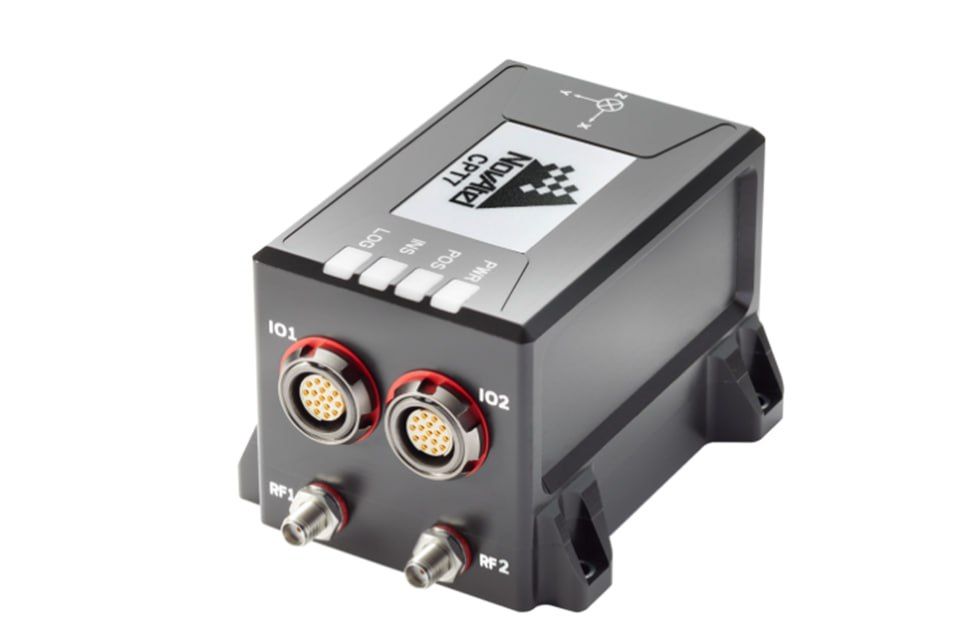
The CPT7 is a single-body Global Navigation Satellite System (GNSS) and Inertial Navigation System (INS) receiver powered by Hexagon's OEM7 technology | NovAtel and provides centimeter accuracy. Two antennas provide the user with heading information and fast alignment of a combined GNSS + Inertial solution. The CPT7 is lightweight, ultra-compact, and offers a low-power solution with multiple communication interfaces for easy integration. The CPT7 contains a high-performance Honeywell HG4930 Micro Electromechanical System (MEMS) inertial measurement unit (IMU) that implements NovAtel's world-class SPAN technology in an integrated solution. SPAN technology deeply integrates GNSS positioning and the stability of IMU gyro and accelerometer measurements to improve satellite tracking and provide the most continuous positioning determination.
    Functions:
    - MEMS gyroscope and accelerometers;
    - SPAN GNSS+INS capabilities with customizable application profiles;
    - Advanced interference suppression functions;
    - Two antennas, direction (course) ALIGN;
    - Wheel sensor (DMI);
    - Option to purchase upgrade for high data rate IMU (up to 400Hz);
    - Internal registration and data transfer (16 GB);
    - Four receiver status LEDs;
    - Input and output events to support 1 PPS;
    - Several communication interfaces.

Tracking signals
GPS
L1 C/A, L1C, L2C, L2P, L5
GLONASS
L1 C/A, L2 C/A, L2P, L3, L5
Galileo
E1, E5 AltBOC, E5a, E5b
BeiDou
B1I, B1C, B2I, B2a, B2b
SBAS
L1, L5
Accuracy of measurements (SCP):
Autonomous L1/L2
1.2 m
RTK
1 cm + 1 ppm
SBAS
60 cm
TerraStar-L
40 cm
TerraStar-C PRO
2.5 cm
Accuracy of time determination
< 5 нс
Speed determination accuracy
< 0,03 m/s
Speed ​​limit
600 m/s
Accuracy of the ALIGN course (RMS)
The baseline is 2 m
0.08 degrees
The baseline is 4 m
0.05 degrees
Productivity
Instantly
5 cm or 5%
Delay
3.5 cm or 3.5%
Post-session processing (Inertial Explorer)
2.5 cm or 2.5%
Maximum data transfer rate
GNSS measurements
up to 20 Hz
GNSS position
up to 20 Hz
Decision of the INS
up to 200 Hz
IMU raw data transfer rate
100 Hz or 400 Hz
Gyroscope performance (MEMS technology)
Dynamic range
400 °/s
Shear instability
0.45 °/h
Angular random walk
0,06 °/√h
Accelerometer performance (MEMS technology)
Dynamic range
20 g
Displacement instability
0,075 мg
Random walk rate
0,06 м/с/√год
Physical characteristics
Working temperature
-40°C to +71°C
Humidity
95% non-condensing
Size
90 x 60 x 60 mm
Weight
500 grams
Consumer power
9 W (typical)
Feeding
from +9 to +32 V DC
The output voltage of the antenna supply
5 V DC ±5%
Maximum current per antenna
200 mA
Ports
1 RS-422
до 460,800 біт\с
1 RS-432
до 460,800 біт\с
1 Ethernet
10/100 Mbps
1 CAN Bus
1 Mbps
1 USB
HS
3 Event
entry
3 Event
output + input of the wheel sensor
Є.П.С.South Surveying & Mapping InstrumentsCarlson Software, Inc.NovAtel Inc.SeptentrioCalianЄ.П.С.South Surveying & Mapping InstrumentsCarlson Software, Inc.NovAtel Inc.SeptentrioCalian