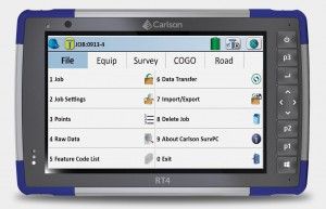
Carlson RT4: A highly secure tablet that is specially designed to support surveying, staking, construction control and GIS mapping. Comes bundled with Carlson SurvPC GNSS software, a Windows 10-based data acquisition program and Esri OEM software in the field. In addition, the tablet can effectively work as a desktop PC with Carlson office applications. 8 GB of LPDDR4 RAM, a quad-core Intel Pentium N4200 processor and a large amount of internal memory will allow you to collect and analyze data faster than ever.
CHARACTERISTICS
Operating system: Microsoft ® Windows 10. Processor: quad-core Intel Pentium N4200. RAM: 8 GB (LPDDR4).
Flash memory: 128 GB. Display: High-definition LCD display for best-in-class sunlight visibility.
Resolution: WXGA (1280 x 800).
Active area of display visibility: 7” (178 mm).
Bluetooth® v5.0 long range +EDR, Class 1.5 + BLE support.
Wi-Fi 802.11 a/b/g/n/ac, 2.4 GHz and 5 GHz.
4G LTE module (GPRS).
Built-in high-performance GNSS chip, 8 MP main camera and 2 MP front camera.
Power supply: removable lithium-ion battery, 10600 mAh.
Physical parameters:
Size: 137 x 215 x 35mm.
Weight: 680 g (907 g with an additional battery).
Impact-resistant construction.
Protection against dust and moisture IP68.
Operating temperature: from -20 ° C to +50 ° C.
BUILT-IN GNSS MODULE
Accuracy: 2.5m offline.
Built-in uBlox NEO-M8N module with the ability to connect an external antenna and obtain submeter accuracy, GPS/QZSS L1 C/A, GLONASS L10F, BeiDou B1 SBAS L1 C/A: WAAS, EGNOS, MSAS, GAGAN Galileo E1B/C, 72 channels.Possibility of post-processing of observations.
BATTERY:
• Removable Li-Ion with a continuous working time of 12 to 15 hours.
• Optimized for temperature range operation from -20 ° C to +50 ° C.
STANDARD KIT:
• Tablet.
• Removable battery.
• Charger.
• Capacitive stylus.
• Hand strap.
• Protective port cover.
Warranty: 24 months.
 Contact us