Kutomir-D
Kutomir-D
GNSS receiver for determining angular orientation
On request
On order
Kutomir-D

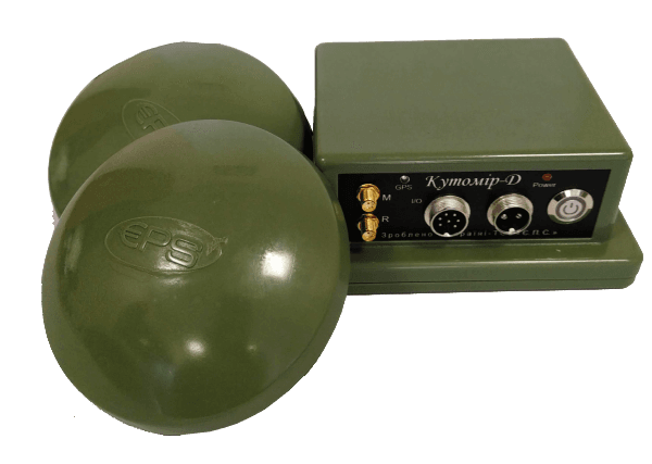
The two-antenna GNSS receiver "KUTOMIR-D" is designed to determine in real time: current geographic coordinates, height (ellipsoidal and orthometric), components of the velocity vector, parameters of the state of the time scale, as well as the true azimuth and angle of the base line formed by the antennas. All parameters are determined by global navigation satellite systems (GNSS) GPS and GLONASS signals in the L1 and L2 frequency bands (Beidou and Galileo signals are optionally available). Solutions are based on NovAtel ALIGN technology.

Accuracy of measurements (RMS):
Standalone L1/L2 (СКП)
1.2 m
SBAS
0.6 m
DGPS
0.4 m
Azimuth real
0.08 grad (baseline 2 m)
Elevation
0.08 grad (baseline 2 m)
Time
20 ns
Velocity
0.03 m/s
Initialization
Cold start
<50 s
Warm start
<35 s
Temp
to 20 Hz
Features
Electrical supply
12…36 V DC
Power consumption
<2 W
Temperature
-40 … +65° C
Humidity
95% (non cond)
Protection
vibration and shock resistant
Size and weight
Size
150x100x50 mm
Weight
350 g
Є.П.С.South Surveying & Mapping InstrumentsCarlson Software, Inc.NovAtel Inc.SeptentrioCalianЄ.П.С.South Surveying & Mapping InstrumentsCarlson Software, Inc.NovAtel Inc.SeptentrioCalian