NovAtel SMART7:multi-frequency and multi-system GNSS reception with an antenna in one housing

NovAtel SMART7:multi-frequency and multi-system GNSS reception with an antenna in one housing
Integrated GNSS receiver and antenna
On request
On order
NovAtel SMART7:multi-frequency and multi-system GNSS reception with an antenna in one housing

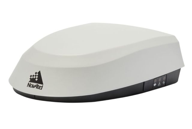
NovAtel SMART7: integrated GPS receiver and antenna with highly stable phase center. The OEM7 receiver and VEXXIS antenna inside the SMART7 allow you to receive GPS, GLONASS, BeiDou, Galileo and QZSS signals. 555 channels of receiving GNSS signals ensure better availability of satellites in changing terrain and environmental conditions. The SMART7 also accepts L-band signals, providing easy access to the correction signals provided by TerraStar. ALIGN technology from Hexagon | The NovAtel is additionally supported in conjunction with a second SMART7 or NovAtel receiver to provide relative heading and position that can be used to guide additional vehicles. Wi-Fi can be used to provide a wireless ALIGN solution to simplify communication in control applications. Thanks to the optional integrated terrain compensation, SMART7 improves navigation and auto steering on uneven terrain and slopes, providing a position that is automatically adjusted according to the angle and roll of the vehicle. SMART7 can provide a range of accuracy and performance from dual-frequency GLIDE to centimeter-level RTK. TerraStar services provide decimeter or centimeter level accuracy using global satellite corrections. SMART7 supports RS-232 and CAN communication. 2.4 GHz Wi-Fi and 10/100 Ethernet option will allow you to connect to the car Wi-Fi network, routers, terminals or other SMART7 antennas. Wi-Fi or Ethernet can be used to receive RTK or TerraStar corrections via NTRIP. SMART7 is built in a rugged, waterproof case that meets MIL-STD-810G environmental standards. Magnetic and screw mounting are supported.

Signal Tracking:
GPS
L1 C/A, L1C, L2C, L2P, L5.
GLONASS
L1 C/A, L2 C/A, L2P, L3, L5.
Galileo
E1, E5 AltBOC, E5a, E5b, E6.
BeiDou
B1I, B1C, B2I, B2a, B2b, B3I.
SBAS
L1, L5.
L-band up to 5 channels
up to 5 channels.
Position determination accuracy (plan, SCP):
Single L1/L2
1,2 m.
SBAS
60 сm.
DGPS
40 сm.
TerraStar-L
40 сm.
TerraStar-C PRO
2,0 сm.
TerraStar-X
2,0 сm
Speed determination accuracy
0,03 m/s
Accuracy of time determination
20 нs
Accuracy of terrain compensation (roll/tilt)
0,5 degrees
Pass-to-pass accuracy (95%)
L1/L2 GLIDE single
35 сm
TerraStar-L
15сm
TerraStar-C PRO
2 сm
Maximum data transfer rate
Measurement
до 20 Hz
Position
up 20 Hz
Physical and electrical characteristics
Dimensions
220 mm (length) x 192 mm (width) x 66 (height) mm
Weight
< 1100 grams
Interface
14-pin (Tyco Ampseal)
Fastening
2 magnets 4 x M4 screw mounts
Feeding
7 - 30 V DC
Power consumption
4 W (typical)
Status indicators
Multicolored, visible in daylight
Input power protection
ISO 7637-2:2004 and ISO 15003
Operating temperature range
-40 ... +70°C
Protection level
IP67
Communication ports
3 - RS-232, 1 - CAN Bus, 1 - 1 PPS output, 1 - movement speed, event marker output
Acceptance of amendments in formats
RTCM versions 2.1, 2.3, 3.0 and 3.1, CMR, CMR+ and RTCA
Output of messages in formats
NMEA-0183 or NovAtel ASCII or binary
Є.П.С.South Surveying & Mapping InstrumentsCarlson Software, Inc.NovAtel Inc.SeptentrioCalianЄ.П.С.South Surveying & Mapping InstrumentsCarlson Software, Inc.NovAtel Inc.SeptentrioCalian