South NaviStation

South NaviStation
South NaviStation
Tachometer with built-in GNSS receiver (up to 2 km)
250,141.00 uah
On order
South NaviStation

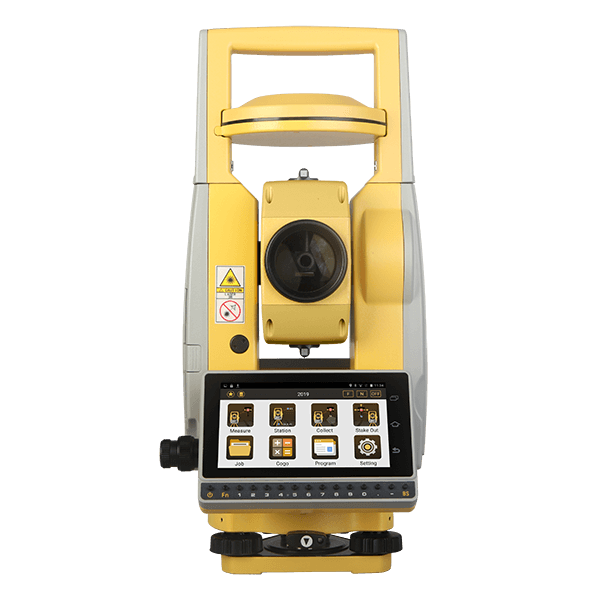
South NaviStation_ is an integrated high-performance system based on Android, consisting of a total station and a GNSS RTK receiver, which is designed to perform combined surveying. Using NaviStation there is no need to lay down the points of plan-altitude justification, calculate and equalize moves, carry out additional processing of total station and GNSS receiver measurements. NaviStation will take care of these time-consuming and costly operations. All you need is to install the device and perform a tacheometric survey, while the coordinates of all standing points will be determined by the GNSS RTK receiver. Full synchronization of the total station and the GNSS receiver will provide a joint coordinate solution not only of course points, but also of all survey points.

Features of the total station
Distance measurement
  • 2000 m Non-prism.
  • Stronger return signal due to Its dual laser technology
  • Accuracy: 2+2ppm
  • Extremely fast (0.3s) speed under fine mode
USB OTG, SD, Bluetooth
  • Flexible transfer of data via PC or PDA
WLAN & 4G Module
  • Quick access to Internet
Operating System
  • Android 6.0.
All Constellations
  • Enable the satellite tracking from BDS, GPS, GLONASS and Galileo
5.0 inch color display
  • Built-in high-resolution anti-glare display.
Alphanumeric keyboard
  • Faster and more comfortable data entry
Distance Measurement with Reflector
Range
5000 m
Accuracy
± (2+2 ppm x D) mm
Measure Interval
Fine: 0.3s, Tracking: 0.1s
Distance Measurement without Reflector
Range
2000 m
Accuracy
± (3+2 ppm x D) mm
Measure Interval
0.3-3s
Angle Measurement
Accuracy
2”
Measure Method (HZ/V)
Absolute Continuous, Diametrical
Diameter of Encoder Disk
79 mm
Display Resolution
0.1”
Compensation
Liquid, Dual Axis Compensation
Compensator Setting Accuracy
1”
Compensator Range
± 4'
Telescope
Image
Erect
Tube Length
154 mm
Effective Aperture
45 mm
Magnification
30x
Resolving Power
3”
Field of View
1°30"
Focusing Range
1.2 m
Reticle
Illuminated, 4 Brightness Level
Vial
Plate Vial
30"/2 mm
Circular Vial
8'/2 mm
Laser Plummet
Type
Laser Class 2/IEC60825-1; 4 Brightness Level
Accuracy
±1.5mm at 1.5M Instrument Height
System Config
Operating System
Android 6.0
Processor
MT6753
Internal Memory
RAM: 3ГБ; ROM: 32ГБ
Satellite Signals
Satellite Tracking
574
Signal Tracking
BDS-2: B1, B2, B3, GPS: L1, L2C, L2P, L5, GLONASS: L1, L2, SBAS
Performance Specification
Time to First Fix
Cold Start <50s, Warm Start <45s
Signal Re-acquisition
< 3 s
RTK Initiation Time
< 15 s
RTK Initiation Reliability
> 99.9%
Positioning Precision
Single Point
Single: H≤3m, V≤5m (1σ, PDOP≤4)
Positioning RTD Surveying
H: ±0.5 m, V: ±1.0 m
Static Surveying
H: ± (2.5 mm+1 ppm x D), V: ± (5 mm+1 ppm x D)
Real-time Kinematic Surveying
H: ± (10 mm+1 ppm x D), V: ± (20 mm+1 ppm x D)
Communication
Interfaces
Serial Port (6-Pin), Micro SIM, USB Type C (OTG), TF Card
Network
2G 900/1800 3G 2100/900 CDMA BC0 TDSCDMA A/F 4G LTE band1/3/7/38/39/40/41
Bluetooth
Bluetooth 4.0
WLAN
Dual-Band Single Stream 802.11 a/b/g/n RF for Data Link
Microphone / Speaker
Available
Others
Display
TFT LCD Screen, Graphics, 720*1280
Battery
Lithium-Ion, 7.4V, Operating 8-10 Hours
Dimension
200 *170 *350 mm, 5.7 кg
Protection
IP55
Temperature Range (Operation)
-20°C…+50°C